Reviewed by our editorial team Updated
Exploring Glasgow by Subway
The Glasgow Subway is the third-oldest underground metro system in the world, opening on 14 December 1896, shortly after London’s Metropolitan Railway and Budapest’s Metro, and remains one of the simplest ways to explore the city. Its small circular layout means you are never more than a few stops from the centre, the West End, or the south side.
Unlike London’s sprawling Underground, the Subway has just fifteen stations on a single loop, so there is no need to study a complicated map or worry about which line to take. You simply choose a direction, inner or outer circle, and go, a simplicity the original operators were so proud of that they advertised the whole network with the slogan “Round the City in Half an Hour” when it first opened.
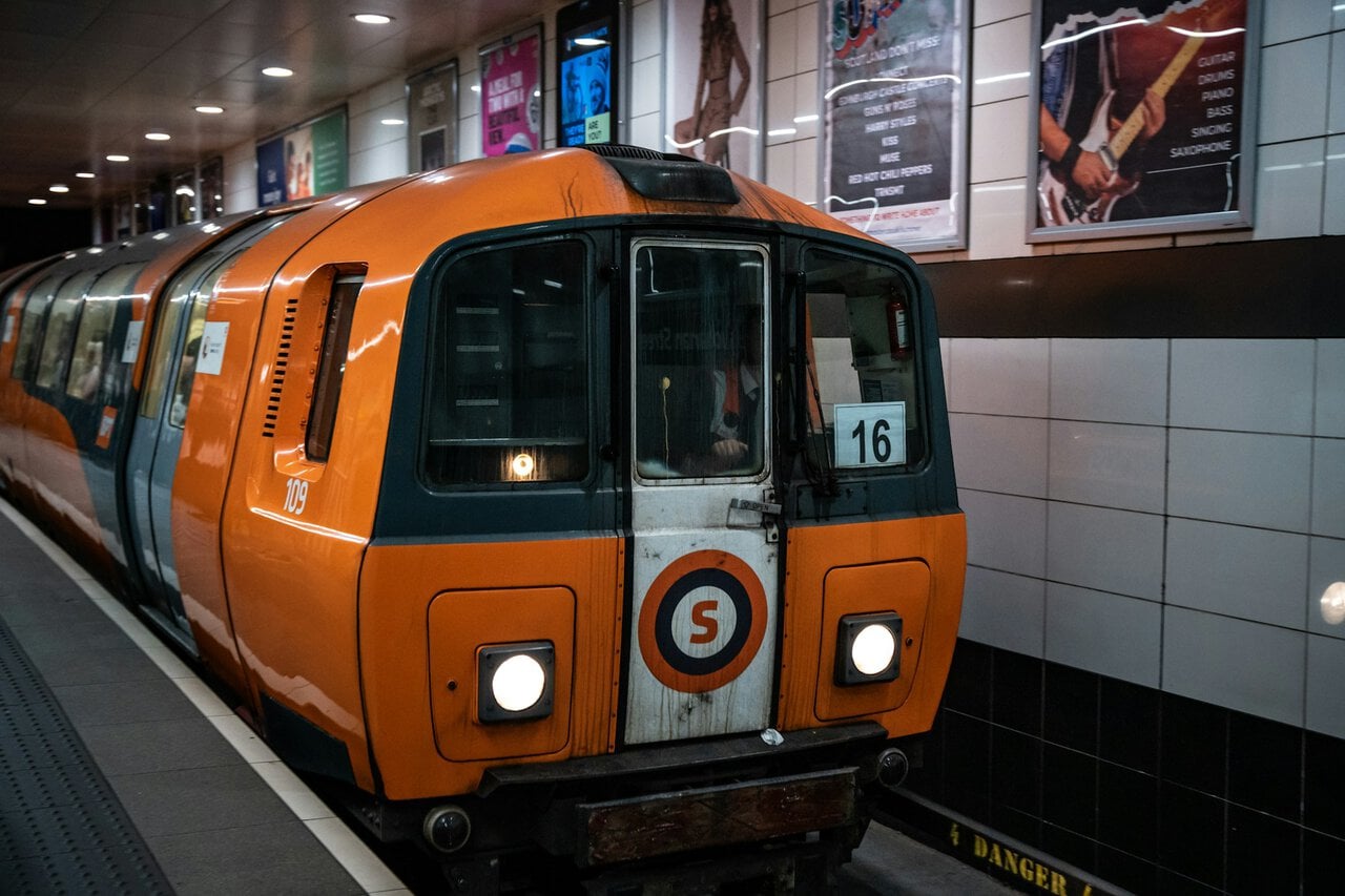
The system was originally cable-hauled, not unlike the cable cars still running in San Francisco, and only switched over to electric power in 1935. It kept operating through both World Wars, at times doubling as an air raid shelter, and underwent a complete rebuild between 1977 and 1980 that gave the network its enduring nickname. Fresh trains introduced as recently as 2023 mean the rolling stock today is thoroughly modern, even if the tunnels themselves have carried passengers since the Victorian era. Today the network carries more than 13 million passenger journeys a year, a genuinely impressive figure for a system covering such a small area of the city.
This guide covers the full network in detail, from fares and ticket types to which stations put you closest to the city’s best attractions. For a broader look at buses, trains, and airport transport, see our Glasgow Public Transport Guide.
Circular Network
The Subway operates as a single circular route, with trains running in both directions, clockwise (outer circle) and anticlockwise (inner circle). A full loop of the system takes just 24 minutes, making it one of the fastest ways to cross the city centre, and remarkably close to the same journey time the network’s earliest passengers would have experienced well over a century ago.
Trains run every four minutes at peak times, with a slightly reduced frequency off-peak. Services operate 06:30 to 23:40 Monday to Saturday, and a shorter 10:00 to 18:12 on Sundays.
Because the network is circular, it is easy to accidentally board a train heading the “long way round” to your destination, a mistake experienced Glaswegians rarely make but first-time visitors almost always do at least once. Checking the platform display for your direction before boarding saves a few unnecessary minutes.
The bright orange line colour used on maps, signage and the trains themselves throughout the city gives the system its popular nickname, the Clockwork Orange, a name coined during the system’s 1977 to 1980 refurbishment that referenced both the trains’ new colour and the fact they run in both directions around the same circular route.
See hotel options and places to stay in Glasgow.
Browse hotelsBrowse apartments, homes and self-catering accommodation in Glasgow.
Browse rentalsCompare prices for Glasgow hotels across multiple booking sites.
Check dealsBuying Tickets and Fares
The simplest way to pay is by tapping a contactless bank card or mobile wallet directly at the gates, a feature that rolled out across every station on the network in March 2026. Single fares cost £1.80, with spending automatically capped at £3.40 for the day and £15.50 for the week when the same card is used throughout, a system that has made the whole network noticeably easier to navigate for visitors unfamiliar with Glasgow’s fare structure.
Paper tickets remain available on the day of travel, priced at £1.85 for a single, £3.50 for a return, and £4.45 for an all-day ticket. These cost slightly more than contactless, so they suit visitors who prefer not to use a card, or anyone whose bank does not offer favourable rates on contactless transactions abroad.
Regular visitors or longer-stay travellers can register a Subway Smartcard for £5, unlocking season tickets and pay-as-you-go balances, including a 28-day pass at £60 and a 7-day pass at £15.50. Children under five travel free with a fare-paying adult.
Our Glasgow Public Transport Guide compares the Subway against ZoneCard and Roundabout tickets if your trip also involves buses or trains.
Best Apps for Using the Subway
The official SPT Subway app, available for both Apple and Android, is the most useful download if you plan to rely on the network throughout your stay. It lets you buy mobile tickets in advance and display a QR code at the gate, which is genuinely handy if you would rather sort out your tickets on the train or in your hotel than queue at a machine after landing.
Now that contactless tap-in and tap-out has rolled out fully across the network, many visitors find they do not need a dedicated ticketing app at all, since a normal bank card or phone wallet handles fares automatically with the same daily and weekly caps as the Smartcard. For anyone who would rather see fares tracked in one place, the SPT app still lets you check your transaction history once registered.
For journey planning rather than ticketing, Google Maps covers the Subway alongside Glasgow’s buses and trains, and is generally the simplest option if you already use it for everything else. It will factor in walking time to and from stations, which the Subway’s own printed map obviously cannot do.
For wider journeys across Scotland involving buses that the Subway does not reach, the Traveline Scotland app remains the most comprehensive option, pulling together timetables from operators across the whole country rather than just SPT’s own network.
Whichever apps you use, downloading them and creating any necessary account before you fly, rather than trying to do it on patchy airport Wi-Fi, will save a few minutes of frustration on your first journey into the city.
Fifteen Stations
Travelling clockwise from the West End, the loop runs: Partick, Kelvinhall, Hillhead, Kelvinbridge, St George’s Cross, Cowcaddens, Buchanan Street, St Enoch, Bridge Street, West Street, Shields Road, Kinning Park, Cessnock, Ibrox, and Govan, before returning to Partick, exactly the same fifteen stops the network has served since it first opened, with the layout of the loop itself never having been expanded in well over a century.
The table below gives a quick sense of what each station is actually useful for, since station names alone rarely mean much to a first-time visitor.
| Station | Why You’d Use It |
|---|---|
| Partick | Interchange with ScotRail suburban trains; gateway to the West End |
| Kelvinhall | Kelvingrove Art Gallery and Museum, University of Glasgow, Riverside Museum area |
| Hillhead | Byres Road cafes and bars, Ashton Lane, the heart of student West End life |
| Kelvinbridge | Botanic Gardens and the Kibble Palace, quieter West End streets |
| St George’s Cross | Woodlands and Woodside neighbourhoods, northern end of Great Western Road |
| Cowcaddens | Glasgow Royal Concert Hall, Theatre Royal, Glasgow School of Art |
| Buchanan Street | Buchanan Street shopping, interchange with Queen Street Station; the busiest stop on the network |
| St Enoch | St Enoch shopping centre, interchange with Glasgow Central Station |
| Bridge Street | Citizens Theatre, O2 Academy Glasgow, main interchange with south side buses |
| West Street | Tradeston and Kingston; a quiet, mainly residential stop with the fewest passengers on the network |
| Shields Road | Residential south side streets on the Pollokshields fringe |
| Kinning Park | Residential south side neighbourhood, useful if staying in this pocket of the city |
| Cessnock | Residential streets close to Ibrox, a quieter alternative approach on match days |
| Ibrox | Ibrox Stadium on match days |
| Govan | South bank of the Clyde, Govan’s shipbuilding heritage, one of only two fully wheelchair-accessible stations |
Hillhead and Kelvinbridge sit at the heart of the West End’s cafe and student culture, while Kelvinhall is the closest stop to Kelvingrove Art Gallery and the Riverside Museum area. Ibrox serves Ibrox Stadium on match days, and Govan gives access to the south bank of the Clyde, an area that was once at the heart of Glasgow’s shipbuilding industry.
In the city centre, Buchanan Street and St Enoch are the two busiest stations, sitting right in the main shopping and dining districts and doubling as interchanges with the mainline rail network. Buchanan Street alone recorded around 2.48 million passenger journeys in 2024, making it comfortably the busiest single stop on the entire loop.
Every station has step-free access guides published by SPT, detailing exactly which stops have lifts, escalators, or stairs only, which is worth checking in advance if this matters for your journey. St Enoch and Govan are currently the only two stations offering full wheelchair-accessible step-free routes from street to platform.
Interchanging with Trains and Buses
Three Subway stations connect directly with the wider transport network. Partick is a major interchange with ScotRail suburban and regional services, useful for reaching the west of the city and beyond. Buchanan Street connects with Glasgow Queen Street station via a travelator beneath the street, and St Enoch connects with Glasgow Central, the city’s two main rail terminals.
These interchanges make the Subway a natural first or last leg of a longer journey, whether you are arriving by train from elsewhere in Scotland or continuing on toward the airport or the coast, and knowing them in advance can save a confused walk between stations that look close together on a map but are separated by busy city streets.
First Glasgow buses stop within easy walking distance of most Subway stations, filling in gaps for neighbourhoods the circular route does not reach directly, such as Finnieston or the Scottish Event Campus.
If your journey starts or ends at Glasgow Airport, our Glasgow Airport Transfers guide explains how the Airport Express bus connects into the city centre network.
Top Attractions
Kelvinhall station is the easiest way to reach Kelvingrove Art Gallery and Museum and the surrounding University of Glasgow campus, both firm favourites with first-time visitors. Hillhead offers an alternative approach into the same West End area, with a livelier stretch of cafes and bars along Byres Road.
In the city centre, Buchanan Street and St Enoch place you directly among the main shopping streets and Merchant City’s restaurants, while Cowcaddens is a short walk from the Glasgow Royal Concert Hall and the Theatre Royal.
Our full Things to Do in Glasgow guide lists the nearest Subway station for every major sight in the city, making it simple to plan a route without doubling back on yourself.
If you would rather explore beyond the city, our Day Trips from Glasgow guide covers Loch Lomond, Stirling, and other destinations reachable by train from the city centre.
During Major Events
The Subway gets noticeably busier around major events, particularly on Ibrox match days and during large gatherings such as the Commonwealth Games returning to Glasgow in 2026. Extra caution and a little extra time are worth building into your journey on these days, since the small size of the network that makes it so convenient day to day also means it fills up quickly when a big crowd descends on it at once.
Having a contactless card or ticket ready before reaching the gates helps keep queues moving at busy stations, and travelling just before or after the main crowd surge, rather than exactly at kick-off or chuck-out time, makes for a noticeably smoother trip.
Our Commonwealth Games Glasgow guide covers transport planning for the 2026 Games in detail, including which stations serve each venue.
Checking SPT’s travel alerts on the morning of any major event is a good habit, since temporary service changes are common when large crowds are expected.
Search flights and useful route combinations for your trip.
View flightsBrowse Airalo eSIM options for convenient travel data.
Check eSIMsCheck private pickup options and plan your onward journey before arrival.
View transfersAccessibility
The Subway includes a range of accessibility features across its stations, including induction loops at ticket offices, tactile paving and maps for visually impaired passengers, colour-contrast stair nosings, and double-height handrails, most added during the network’s various modernisation programmes over the decades.
The Thistle Assistance Card helps older passengers and those with disabilities access support when travelling, and station-by-station access guides published by SPT detail exactly which stops have stairs, escalators, or step-free routes.
Assistance dogs are welcome throughout the network, and staff are present at every station during operating hours to help with any accessibility needs that arise.
Because station layouts vary considerably across a system that dates back to 1896, checking the specific access guide for your planned stations ahead of travel is worthwhile if mobility is a concern, since older sections of the network were naturally not built with modern accessibility standards in mind.
Making the Most of Your Journey
Because the loop is so small, the Subway rewards a little planning: grouping nearby attractions together by station rather than crossing the city back and forth saves both time and unnecessary fares.
Travelling just outside peak commuter hours, particularly mid-morning or early afternoon, gives a noticeably calmer experience with more space on trains and shorter waits at busy stations like Buchanan Street.
For visitors staying a few days, pairing the Subway with our Where to Stay in Glasgow guide helps you choose a base within easy walking distance of a station, cutting down on transfers throughout your trip.
Finally, keeping half an eye on the platform display for your direction of travel, clockwise or anticlockwise, avoids the classic first-timer mistake of riding most of the way around the loop by accident, a mistake that costs time rather than money given how the fare structure works.

Rupert’s Handy Travel Tips
Riding the Clockwork Orange for the first time? Here are a few useful tips before you travel:
- Check your direction first: It’s a circle, so boarding the wrong way just means a longer ride, not a wrong destination.
- Tap the same card every time: Daily and weekly price caps only apply if you use one contactless card throughout.
- Group sights by station: Plan your day around nearby stops rather than crossing the loop back and forth.
- Avoid peak Ibrox match times: Trains and platforms get busy right around kick-off and full-time.
Want to meet the reindeer behind our travel tips? Find out more in our page Who is Rupert?.


Frequently Asked Questions
How many stations does the Glasgow Subway have?
Fifteen stations arranged in a single circular loop, with a full circuit taking around 24 minutes.
How much does the Glasgow Subway cost?
A single fare is £1.80, with contactless payment automatically capping spending at £3.40 a day and £15.50 a week.
Which Subway stations connect to National Rail?
Partick connects with ScotRail suburban services, Buchanan Street connects with Glasgow Queen Street, and St Enoch connects with Glasgow Central.
What time does the Glasgow Subway run?
Services operate 06:30 to 23:40 Monday to Saturday, and 10:00 to 18:12 on Sundays.
Is there an app for the Glasgow Subway?
Yes, the official SPT Subway app lets you buy mobile tickets and display a QR code at the gate, though contactless bank cards and mobile wallets now work directly at every station too.
Is the Glasgow Subway accessible?
The network includes induction loops, tactile paving, and the Thistle Assistance Card, though access varies by station, with St Enoch and Govan currently the only fully step-free stops.
Further Reading
For buses, trains, and airport travel alongside the Subway, see our full Glasgow Public Transport Guide, and for arrivals from the airport, our Glasgow Airport Transfers guide covers every option.
Our Things to Do in Glasgow and Where to Stay in Glasgow guides pair well with this one for planning your trip around the network.
Heading to a match or the Games? Our How to Get to Hampden Park and Commonwealth Games Glasgow guides cover event travel in more detail.